ISRO's images show how old landslide triggered Wayanad tragedy
What's the story
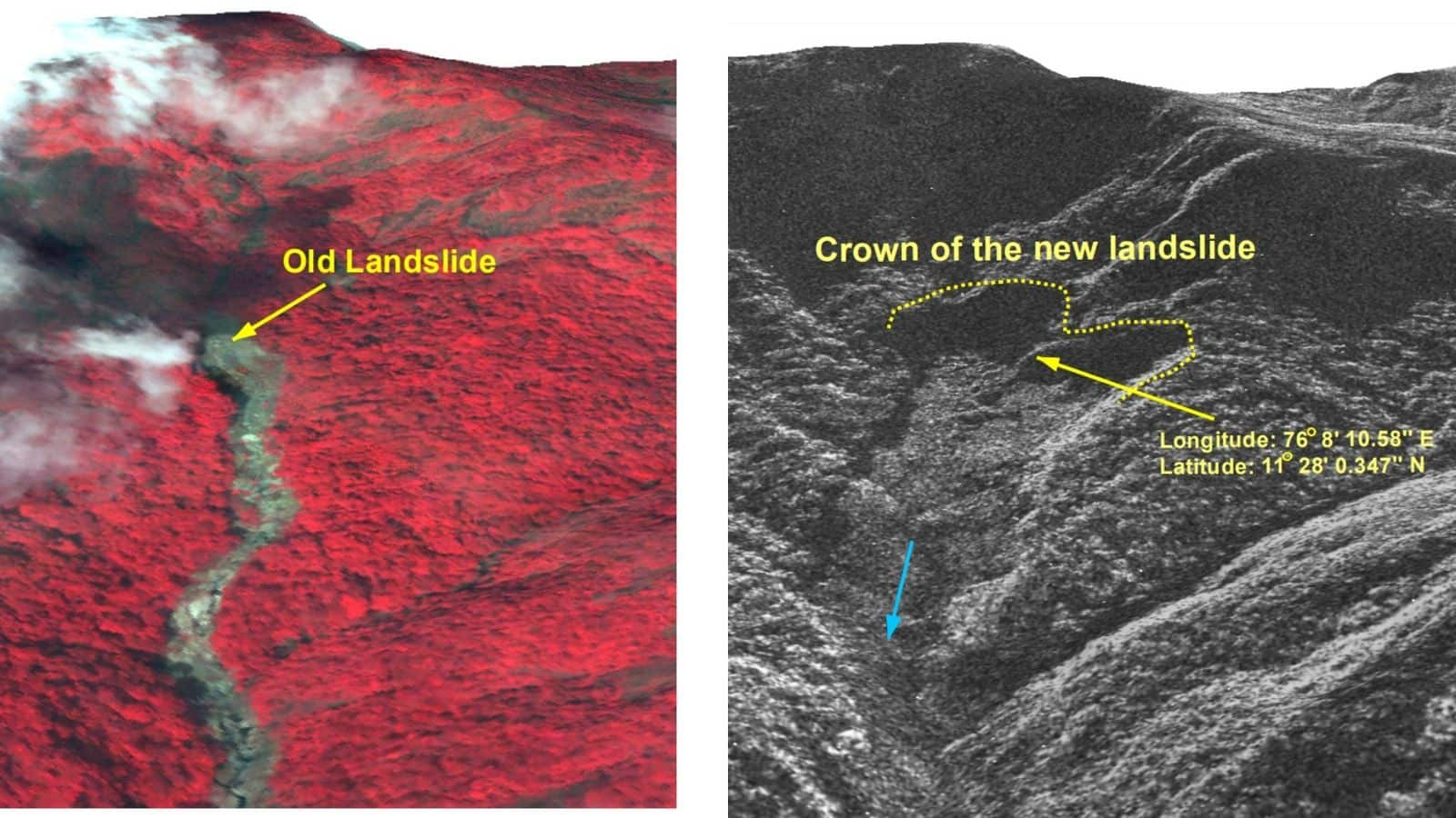
The Indian Space Research Organisation (ISRO) has disclosed that the recent catastrophic landslides in Kerala's Wayanad district started from an area previously impacted by an older landslide. High-resolution imagery from ISRO's National Remote Sensing Center revealed that intense rainfall activated a significant debris flow around Chooralmala town. The event resulted in at least 201 fatalities and approximately 300 missing persons, as per the latest state government updates. However, several other reports suggest that the deaths have crossed the 300 mark.
Damage assessment
Extent of damage revealed by satellite imagery
The landslide led to the Iruvanipuzha River widening and breaching its banks, causing extensive damage to nearby homes and infrastructure. Satellite images from Cartosat 3 taken before the landslide on May 22, 2023, and post-event images from VHR RISAT SAR on July 31, illustrate the magnitude of destruction. The impact covered an area of 86,000 square meters and stretched approximately eight kilometers along a hill slope.
Environmental factors
Climate change, deforestation amplify landslide risks
According to the ISRO's NRSC, 10 out of the 30 most landslide-prone districts in India are located in Kerala, with Wayanad ranking 13th. The Geological Survey of India also says that 0.09 million square kilometers in the Western Ghats and Konkan hills (Tamil Nadu, Kerala, Karnataka, Goa and Maharashtra) are prone to earthquakes. Climate change, fragile terrain, and loss of forest cover are some of the factors that created the ideal conditions for these devastating landslides in Wayanad.
Twitter Post
Check out ISRO's images here
Wayanad, Kerala. #WayanadLandslide
— Neeraj Sharma 🌟⚙️🔋👨🔧🧰🔬🔩 (@Neeraj_Sharma_) August 2, 2024
From @isro Before and After - 3D rendition of the landslide crown illustrates that a large section of the hill slope has been affected.
The National Remote Sensing Center (NRSC) in Hyderabad flew ISRO’s advanced Cartosat-3 optical satellite… pic.twitter.com/ipPox1tkEF
Rainfall impact
Extreme rainfall triggers deadly landslides
The landslides in Wayanad were set off by an extreme rainfall on Tuesday. The district received 572mm of rainfall within a span of 48 hours. The first landslide was reported in Mundakkai town around 2:00am, followed by a second one in Chooralmala, located 3.5km away, around 4:10am. According to reports, rescue efforts in the landslide-hit areas have been hampered due to the extreme weather, damaged roads and bridges, a shortage of heavy equipment, and the treacherous terrain.
Missed warnings
Ignored recommendations could have prevented tragedy
Meanwhile, the Times of India reported that the tragedy could have been averted had the state acted on recommendations from a high-level committee of the Kerala State Disaster Management Authority (KSDMA) four years prior. The committee had advised the urgent relocation of 4,000 families living on the eastern slopes of the Western Ghats in Wayanad due to their vulnerability to landslides.